 Tweet
Tweet
SBNF Motor Vehicle Use Map (MVUM)
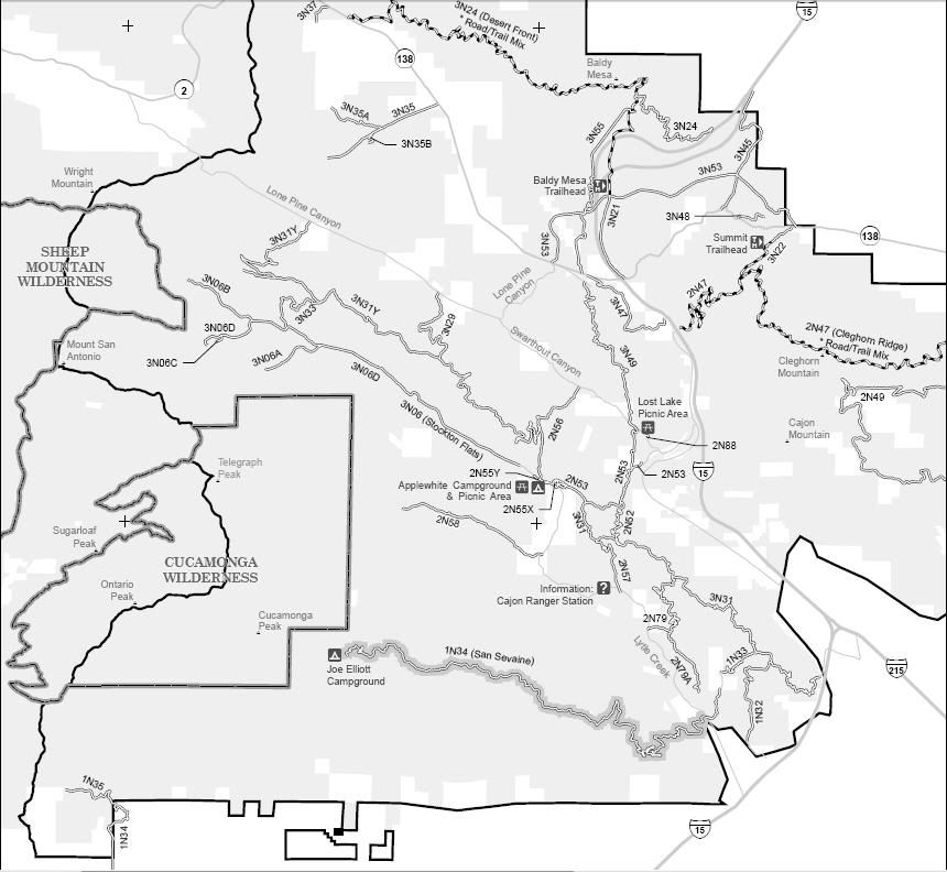
Lytle Creek/Cajon area of the San Bernardino National Forest
Borders:
Mt Baldy to the West
Hesperia/Phelan to the North
Silverwood Lake to the East
Interstate 15/215 to the South
1N31 Sycamore
1N32 Power Line
1N33
1N34 San Sevaine
1N35 Cucamonga Canyon
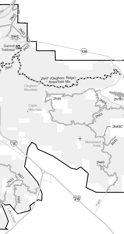
2N43 Monument Peak
2N45
2N47 Cleghorn
2N48
2N49 Bailey Canyon
2N49C
2N52 Purcell
2N53 Applewhite
2N55X Applewhite Campground
2N55Y
2N56 Sheep Canyon
2N57 Sewer Pond
2N58
2N59 Cottonwood
2N79 Turk Point
2N79A Penstock Ridge
2N88 Lost Lake
3N06 Stockton Flats
3N06A Coldwater Canyon
3N06B Paiute Canyon
3N06C
3N06D
3N21 Trestles
3N22 Summit
3N24 Baldy Mesa
3N29
3N31 Lower Lytle Creek Ridge
3N31Y Sheep Creek
3N31YA Gobbler's Knob
3N33
3N35 Macapa
3N35A
3N35B
3N37 Cajon Canyon
3N45
3N47
3N49
3N53 Summit Post Office
3N55 Davis Ranch
3N58
Lytle Creek Yellow Post Camping
SBNF Motor Vehicle Use Map (MVUM)
SBNF Google Earth file
It is always a good idea to call the ranger station before heading in to the forest and get a current conditions report. Lytle Creek Ranger Station (909) 382-2851
Lytle Creek/Cajon area of the San Bernardino National Forest
Borders:
Mt Baldy to the West
Hesperia/Phelan to the North
Silverwood Lake to the East
Interstate 15/215 to the South
1N31 Sycamore
1N32 Power Line
1N33
1N34 San Sevaine
1N35 Cucamonga Canyon
2N43 Monument Peak
2N45
2N47 Cleghorn
2N48
2N49 Bailey Canyon
2N49C
2N52 Purcell
2N53 Applewhite
2N55X Applewhite Campground
2N55Y
2N56 Sheep Canyon
2N57 Sewer Pond
2N58
2N59 Cottonwood
2N79 Turk Point
2N79A Penstock Ridge
2N88 Lost Lake
3N06 Stockton Flats
3N06A Coldwater Canyon
3N06B Paiute Canyon
3N06C
3N06D
3N21 Trestles
3N22 Summit
3N24 Baldy Mesa
3N29
3N31 Lower Lytle Creek Ridge
3N31Y Sheep Creek
3N31YA Gobbler's Knob
3N33
3N35 Macapa
3N35A
3N35B
3N37 Cajon Canyon
3N45
3N47
3N49
3N53 Summit Post Office
3N55 Davis Ranch
3N58
Lytle Creek Yellow Post Camping
SBNF Motor Vehicle Use Map (MVUM)
SBNF Google Earth file
It is always a good idea to call the ranger station before heading in to the forest and get a current conditions report. Lytle Creek Ranger Station (909) 382-2851