 Tweet
Tweet
Death Valley National Park
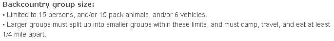
DVNP Road and Vehicle Rules and Regulations
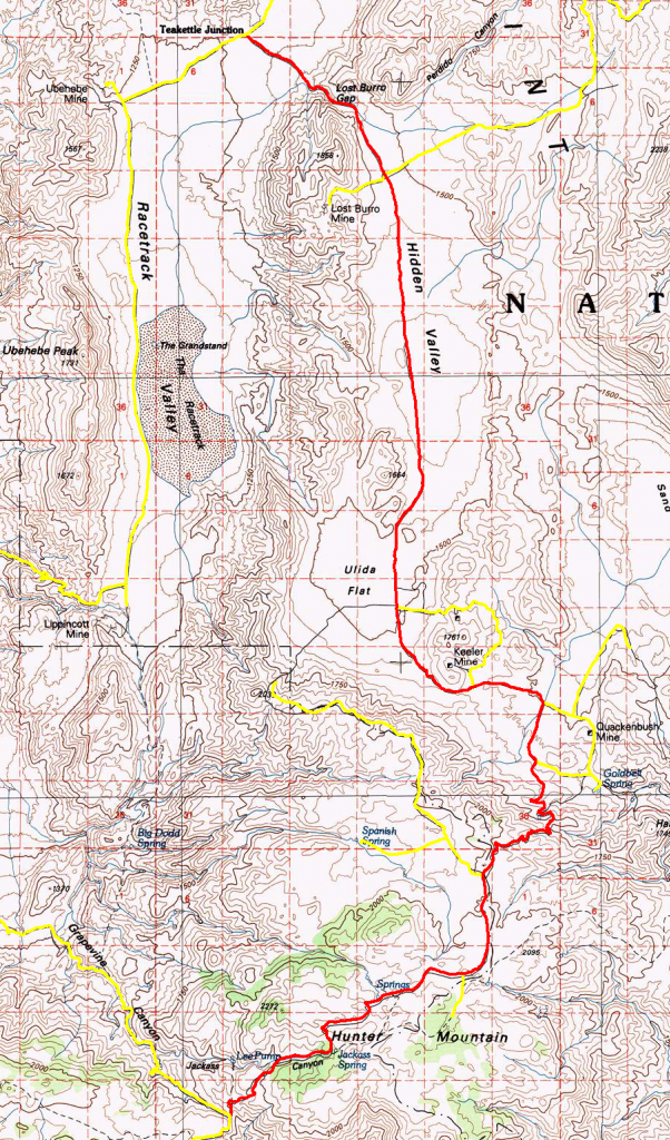
DVNP Backcountry Map

http://www.topo.com
Elevation 4150' to 6500'
North Entrance at Teakettle Junction/Race Track Valley Road at N36� 45.591 W117� 32.542
White Top Mountain Exit at N36� 43.806 W117� 30.331
Lost Burro Mine Exit at N36� 43.782 W117� 30.318
Keeler Mine/Ubehebe Talc Mine Loop North Entrance at N36� 38.196 W117� 30.120
Keeler Mine/Ubehebe Talc Mine Loop South Entrance at N36� 37.149 W117� 28.909
Quackenbush Mine Loop North Entrance at N36� 36.953 W117� 27.779
Quackenbush Mine Loop South Entrance at N36� 36.199 W117� 27.894
J.O. Mine/Ulida Flats Overlook Road Exit at N36� 34.703 W117� 28.744
Hunter Spring Exit at N36� 33.442 W117� 29.065
Saline Valley Road Entrance/South Pass at N36� 31.605 W117� 32.805
Lat/Lon format is hddd� mm.mmm WGS84 datum
It is always a good idea to call the Death Valley National Park Ranger Station before heading in to the desert and get a current conditions report. (760) 786-3200
Death Valley National Park Emergency Dispatch (888) 233-6518
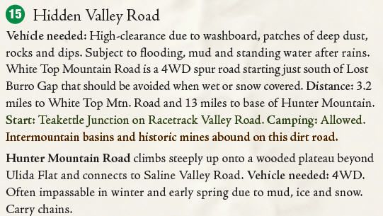
DVNP Road and Vehicle Rules and Regulations
DVNP Backcountry Map
http://www.topo.com
Elevation 4150' to 6500'
North Entrance at Teakettle Junction/Race Track Valley Road at N36� 45.591 W117� 32.542
White Top Mountain Exit at N36� 43.806 W117� 30.331
Lost Burro Mine Exit at N36� 43.782 W117� 30.318
Keeler Mine/Ubehebe Talc Mine Loop North Entrance at N36� 38.196 W117� 30.120
Keeler Mine/Ubehebe Talc Mine Loop South Entrance at N36� 37.149 W117� 28.909
Quackenbush Mine Loop North Entrance at N36� 36.953 W117� 27.779
Quackenbush Mine Loop South Entrance at N36� 36.199 W117� 27.894
J.O. Mine/Ulida Flats Overlook Road Exit at N36� 34.703 W117� 28.744
Hunter Spring Exit at N36� 33.442 W117� 29.065
Saline Valley Road Entrance/South Pass at N36� 31.605 W117� 32.805
Lat/Lon format is hddd� mm.mmm WGS84 datum
It is always a good idea to call the Death Valley National Park Ranger Station before heading in to the desert and get a current conditions report. (760) 786-3200
Death Valley National Park Emergency Dispatch (888) 233-6518


Comment