 Tweet
Tweet
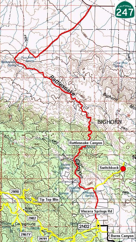
Rattlesnake Canyon is an authorized motor vehicle route through the Bighorn Wilderness.
Length: 9 miles, 16 miles from Hwy 247 to Burns Canyon Rd
Time to complete: 2 hours.
Rattlesnake Canyon can be found in the San Bernardino National Forest. The favored direction of travel is from 3/4 of a mile East of mile marker 27 on Highway 247 to 2N02 and Big Bear Lake. Rattlesnake Canyon is available to street legal vehicles and green sticker vehicles.
The US Forest Service rates this trail a blue square more difficult route. You can expect to encounter soft sand, multiple stream crossings and small rocky sections. Elevation ranges from 3800' to over 5700'.
Hwy 247 turnoff is N34� 22.195 W116� 39.045.
Entrance to Rattlesnake Canyon is N34� 20.285 W116� 42.440.
Rattlesnake Canyon turns into Viscera Springs Rd at N34� 15.478 W116� 38.964.
Viscera Springs Rd/Burns Canyon/2N02 intersection is N34� 14.165 W116� 38.798.
Lat/Lon format is hddd� mm.mmm and WGS84 datum
Comment